Long before Lake Superior, Lake Michigan, Lake Huron, Lake Erie, and Lake Ontario became the defining waters of North America, a far larger lake spread across the center of the continent.
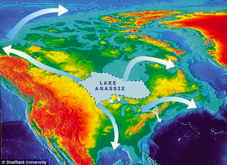
Lake Agassiz no longer appears on any map. It drained away after the last ice age. Still, its scale remains hard to ignore. More than 10,000 years ago, this prehistoric inland sea covered about 170,000 square miles, an area so vast it exceeded the combined size of the Great Lakes.
That kind of size changes more than a shoreline.
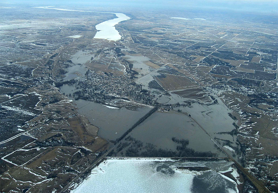
It helped carve valleys, fill basins, redirect rivers, and reshape the weather across a huge swath of land. Even now, the marks it left behind remain visible in the Red River Valley and in the many lakes and wetlands scattered across the region.

The Great Lakes are hardly small. Lake Superior alone covers more than 31,000 square miles. Michigan and Huron, if treated as one connected system, span about 45,300 square miles together. As a group, the Great Lakes hold 21% of Earth’s surface fresh water. Yet even that collection looks modest beside what Lake Agassiz once was.
Lake Agassiz formed as the Laurentide Ice Sheet began to retreat. That ice sheet had once covered much of North America. As it melted, huge volumes of water poured into low-lying ground and began pooling into enormous lakes. Agassiz became the biggest of them.
Fed by rivers including the Red River of the North, the Minnesota River, and the Winnipeg River, the lake expanded over time into an immense inland sea. In some places, it reached depths of more than 700 feet. At its peak, it held more water than all of the Great Lakes combined.
Its footprint was astonishing. The lake stretched across much of central Canada and parts of the northern United States, from near the Rocky Mountains toward the Appalachians. Its reach extended from the Arctic Ocean region down toward the Gulf of Mexico. For a period in the continent’s history, this was one of the dominant geographic features of the landscape.
The lake was named after Louis Agassiz, the Swiss-American naturalist who first proposed its existence in the 1800s. What sounded like a bold idea then is now treated as a major part of North America’s glacial past.
But Lake Agassiz did not just sit there as a giant pool of cold water.
Its presence altered wind patterns, making nearby areas wetter and more humid. That means the lake did not simply reflect climate conditions around it. It helped create them.
The effects stretched beyond weather. The lake influenced ecosystems and shaped the routes taken by animals and early human populations moving across the continent. As people spread into new territory, the contours left by this giant water body helped direct where movement was easier, where resources gathered, and where landscapes opened up or closed off.
Then came one of the most dramatic chapters in its history.
At the lake’s southern edge, glacial ice formed a dam that blocked its waters from draining into the Mississippi River. As the lake rose, pressure built against that frozen barrier. Eventually, the dam failed.
The flood that followed was catastrophic. Water surged across parts of what are now the northern United States and Canada, cutting deep channels into the land. The event helped create major features such as the Grand Coulee and the Columbia River Gorge. Sediment from the flood has been found as far south as the Gulf of Mexico, and the outpouring altered the courses of large rivers, including the Missouri and the Mississippi.
A vanished lake had rewritten the continent while it was still disappearing.
Although Lake Agassiz drained completely, scientists are still piecing together its story. One of the most important tools has been sediment cores taken from the former lake bed. These layered samples preserve a record of environmental conditions from the last ice age and the period when the ice sheet retreated and the lake finally drained.
Those cores have offered clues about far more than one lake. They have helped researchers reconstruct North America’s climate and ecology during that period, along with changes in plants, animals, and human movement.
They have also pushed against an older, simpler picture of the ice age.
For years, the common view held that much of North America was uniformly cold and dry during that time. Evidence from Lake Agassiz suggests conditions were more unstable than that, with notable swings in temperature and precipitation. Researchers tie those shifts to several possible forces, including ocean circulation, solar activity, and changes in atmospheric circulation.
That does not mean every question is settled. Scientists are still studying the lake’s history and its full impact, which makes this an active area of research rather than a closed case. Much of what is known comes from the physical record preserved in sediments, and that record continues to be interpreted.
Lake Agassiz also matters beyond paleoclimate and geology. For many Indigenous communities, the lake and its surrounding lands carry cultural and spiritual importance. Efforts in recent years have sought to include Indigenous knowledge and perspectives in research tied to the lake’s history and legacy.

One example comes from the University of Manitoba’s Centre for Earth Observation Science, which has worked with Indigenous communities to build a shared understanding of the lake’s significance. That work has also underscored the need for stronger collaboration between Indigenous and non-Indigenous researchers and decision-makers.
The lake’s legacy continues in practical ways as well. The lakes and wetlands left behind after its drainage provide water filtration, carbon sequestration, and habitat for wildlife. Yet those same ecosystems face pressure from habitat loss, fragmentation, pollution, and climate change.
Collaborative management efforts have emerged in response. The Lake Winnipeg Basin Initiative, for instance, brings together Indigenous and non-Indigenous stakeholders to improve the health and resilience of the watershed.
Lake Agassiz is gone. Its consequences are not.
Lake Agassiz helps explain how large water bodies can reshape climate, ecosystems, and river systems on a continental scale.
It also gives scientists a deeper record of past climate variability, which can sharpen how modern environmental change is understood.
Just as important, these findings support better protection of wetlands and freshwater systems that trace their origins to that ancient lake, while also encouraging a more inclusive approach to managing landscapes with both scientific and cultural significance.
The original story “The lost inland sea that dwarfed the Great Lakes and reshaped North America” is published in The Brighter Side of News.
Like these kind of feel good stories? Get The Brighter Side of News’ newsletter.
The post The lost inland sea that dwarfed the Great Lakes and reshaped North America appeared first on The Brighter Side of News.

