A reef taller than many skyscrapers remained absent from detailed maps beneath the waters off northern Australia. Rising more than 500 meters, approximately 1,640 feet, it reaches toward the surface from a much deeper seabed. Its summit still lies about 40 meters underwater.
Australian scientists identified the structure on October 20, 2020, while surveying the northern Great Barrier Reef. Robin Beaman of James Cook University led the expedition aboard Schmidt Ocean Institute’s research vessel Falkor.
The original expedition announcement described the first discovery of a tall detached reef in the region in more than 120 years. Its importance extended beyond height. Mapping exposed a substantial habitat in a comparatively poorly explored part of an internationally recognized marine ecosystem.
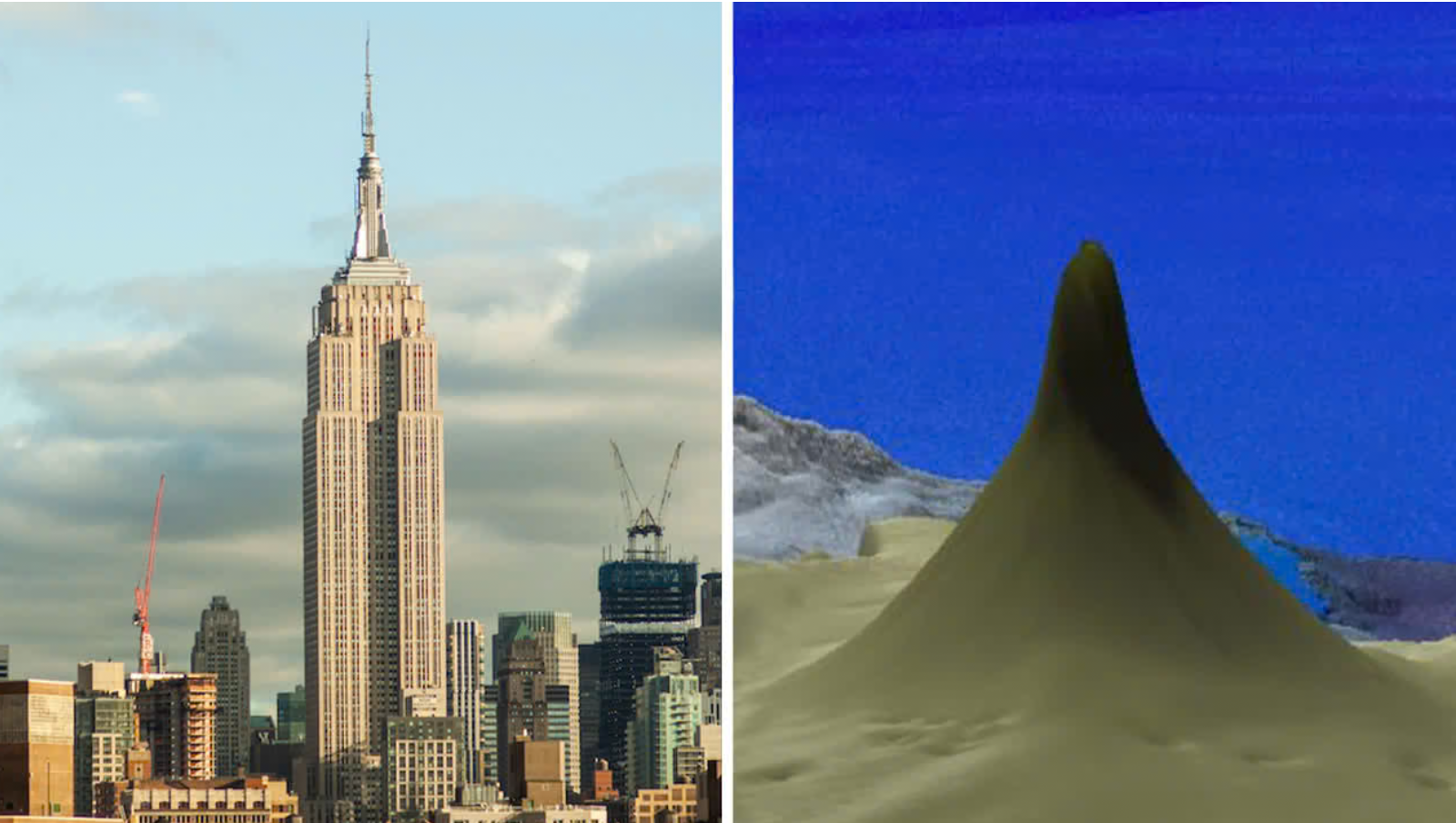
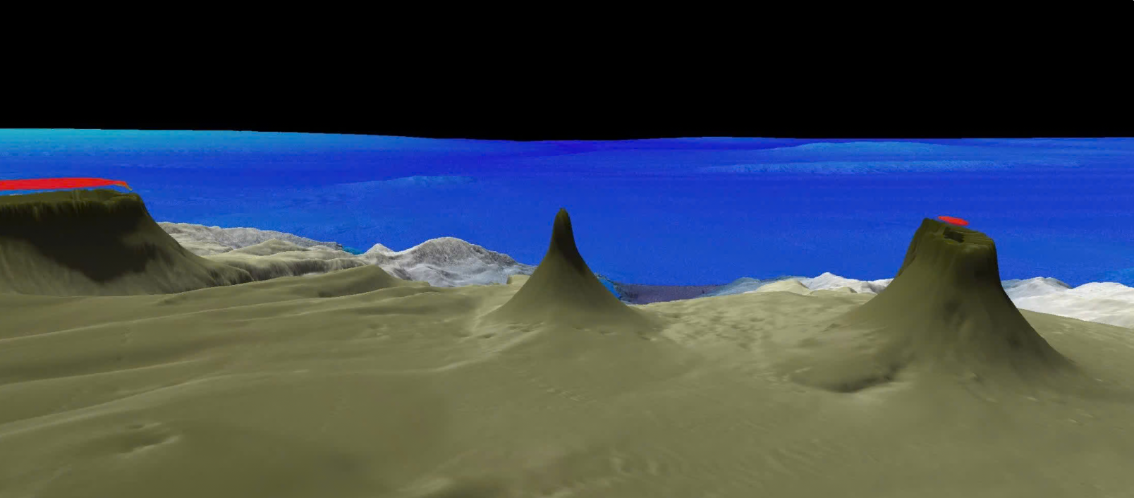
The reef has a broad, blade-like form, with a base approximately 1.5 kilometers wide. Its height measures the rise of the entire structure, rather than a single living coral colony. The shallowest point and the surrounding deep slopes occupy very different underwater settings.
That distinction matters when visualizing the discovery. This is neither an island protruding above the ocean nor one enormous coral animal stretching upward. It is a reef formation with varied surfaces and habitats, revealed through measurements of seafloor topography and subsequent underwater observation.
James Cook University identified the find as an addition to seven other tall detached reefs known in the area. Those neighboring formations had been mapped since the late nineteenth century. The group includes the reef associated with Raine Island, an important green sea turtle nesting location.
Detached reefs are separate structures rather than a continuous extension of a neighboring shallow reef. Their isolation makes detailed surveys important for understanding where habitats occur and how they connect geographically. Discovering another large formation changes the inventory available for those investigations without automatically establishing its age or ecological history.
The expedition used multibeam sonar to map underwater terrain off Cape York Peninsula. This approach measures depths across a swath beneath a vessel, helping researchers reconstruct seafloor shape. The mapping identified the unusual rise before the team examined its surfaces visually.
On October 25, 2020, researchers deployed the remotely operated vehicle SuBastian to explore the reef. Its cameras supplied close views that a depth map alone could not provide. The dive was streamed publicly, allowing viewers to follow the exploration alongside the scientific team.
SuBastian is a tethered research robot equipped for underwater imaging, environmental measurements and sample collection. Schmidt Ocean Institute lists a maximum operating depth of 4,500 meters for the vehicle. Such equipment lets scientists investigate sites beyond ordinary diving depths while retaining direct control from a ship.
Mapping and video answer complementary questions. Sonar establishes the terrain’s dimensions, while imagery helps identify organisms and describe their surroundings. Neither method alone provides a complete ecological assessment, and a visually striking dive is not a substitute for repeated measurements over time.
The Northern Depths of the Great Barrier Reef voyage ran from September 30 to November 17, 2020. Its goals included surveying offshore canyons, detached reefs and submerged older reef structures. Researchers wanted to understand both the region’s geological foundations and the habitats associated with them.
The cruise description emphasized how limited detailed information was for deeper waters offshore of Cape York. Existing maps indicated complicated terrain, but many reef bases remained poorly mapped. Systematic surveys therefore offered a way to investigate features that scattered observations could only suggest.
The work also generated records that other researchers can revisit. The expedition archive links bathymetric grids, annotated imagery, environmental sensor measurements and remotely operated vehicle data. Its final expedition report was deposited publicly in 2024, documenting the voyage rather than announcing a second discovery.
That continuing access matters because discovery is the beginning of a scientific record. Researchers can use archived measurements to examine terrain, revisit interpretations or plan later observations. Determining how an ecosystem changes requires comparable evidence, rather than assuming that an impressive first view describes its condition indefinitely.
The reef’s later naming history adds a useful correction to accounts of the discovery. In 2022, Beaman proposed calling it Falkor Reef in recognition of the research vessel. James Cook University reported the proposal while public consultation was underway.
However, Queensland’s official consultation record states that the proposal did not proceed. The decision, dated August 4, 2023, was not to name the feature Falkor Reef. The earlier announcement should therefore not be treated as confirmation of an adopted name.
The same government record places the feature approximately 70 kilometers northeast of Lockhart River. It also locates it 2.6 kilometers north-northeast of Northern Small Detached Reef. These details offer a more specific geographic description than simply placing the discovery somewhere off Australia.
The latest regional monitoring provides context, rather than a current health assessment of this particular formation. The Australian Institute of Marine Science surveyed 121 reefs between August 2025 and June 2026. Its 2025–26 report found that 28% gained hard coral cover, 56% showed no net change and 16% declined.
Average cover increased in the northern region, while central and southern estimates remained statistically similar to their previous levels. Reduced heat stress and late-summer monsoon cooling offered some relief. Nevertheless, the report identified continuing pressures from warming, cyclones and crown-of-thorns starfish, and recorded severe heat impacts in deeper habitats during 2024.
Globally, the mapping gap also remains large. The GEBCO 2026 update reported that 28.7% of the ocean floor had been mapped to modern standards. That does not mean everything else is wholly unknown, but it underscores the difference between broad ocean maps and detailed seabed surveys. The global grid combines contributions from many organizations, making individual research voyages part of a much larger effort to improve shared knowledge of underwater terrain.
The Cape York discovery illustrates what those surveys can reveal, even within a famous marine region. Its size establishes a remarkable geological feature, not immunity from environmental change. Understanding its future requires the same combination of careful mapping, direct observation and continuing investigation that first brought it into view.
These resources provide expedition records, later administrative decisions and current monitoring context.
Schmidt Ocean Institute Expedition Report: Northern Depths of the Great Barrier Reef: Provides the final report from the 2020 voyage, deposited in a public research repository. (Schmidt Ocean Institute, 2024)
Falkor Reef place name proposal: Records the decision not to proceed with the proposed name and supplies the feature’s location. (Queensland Government, 2023)
Annual Summary Report of Coral Reef Condition 2025/26: Summarizes regional hard-coral-cover measurements and recent disturbances across monitored Great Barrier Reef sites. (Australian Institute of Marine Science, 2026)
Release of the GEBCO_2026 Grid: Explains the latest global bathymetric compilation and the proportion mapped to modern standards. (GEBCO, 2026)
4500 m Remotely Operated Vehicle (ROV SuBastian): Describes the research robot’s imaging, sampling and environmental-measurement capabilities. (Schmidt Ocean Institute, accessed 2026)
The original story “Australia’s 1,640-foot tall coral reef reveals a hidden ocean landscape taller than the Empire State Building” is published in The Brighter Side of News.
Like these kind of feel good stories? Get The Brighter Side of News’ newsletter.
The post Australia’s 1,640-foot tall coral reef reveals a hidden ocean landscape taller than the Empire State Building appeared first on The Brighter Side of News.


Leave a comment
You must be logged in to post a comment.