Three kilometers of ice can hide a lot, but not forever. Beneath East Antarctica, researchers have identified a continent-scale geological structure that ties together some of the region’s best-known buried basins into a single sprawling system, one that may reshape how scientists think about the continent’s deep past and its icy present.
The newly named East Antarctic Fan-Shaped Basin Province stretches from Prydz Bay to the Transantarctic Mountains and from the coast deep into the continent, reaching toward 85° south. It includes the Wilkes and Aurora basins, along with the basin that hosts Lake Vostok, the largest known subglacial lake on Earth.
These features were already familiar on their own. What had not been recognized before was that they form one coherent structure.
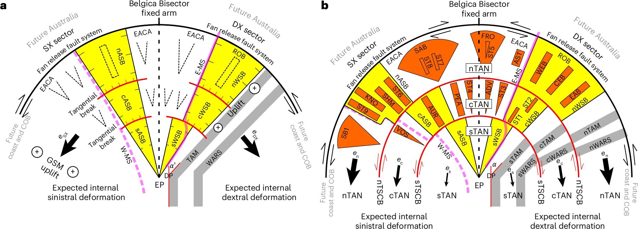
The team at Durham University argues that this buried landscape resembles a handheld fan at a semi-continental scale. Its long basins radiate outward, and its geometry appears to converge near a pivot point close to the South Pole. In the researchers’ interpretation, that pattern points to a powerful tectonic process rather than a collection of unrelated depressions under the ice.
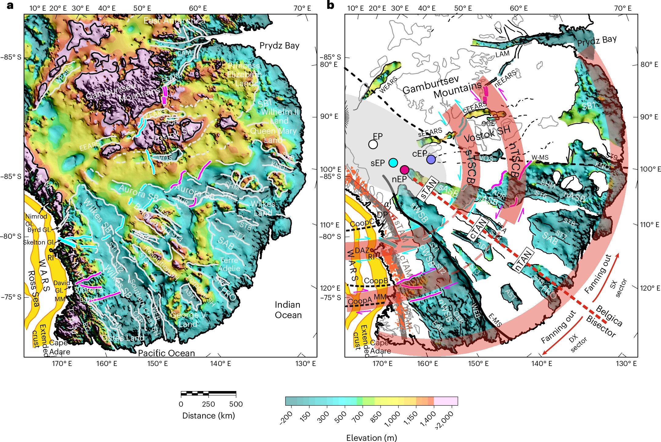
More than 99 percent of Antarctica is covered by ice, so the bedrock beneath it remains one of the hardest landscapes on Earth to map. But improved compilations of radio-echo sounding data have sharpened the picture. In East Antarctica, they reveal a broad, low-lying region where many of the major subglacial basins are aligned north to south and often take on a rough V shape.
When the team analyzed that topography alongside gravity, magnetic, seismic, crustal and lithospheric data, the pattern grew harder to dismiss as coincidence. They identified 30 basins within the province, all arranged in a radial layout centered near a common focal point.
The geometry matters. Researchers fitted the main basin edges to great circles on the globe and estimated a pivot point, or Euler pole, at 86.4° south, 129.9° east. That convergence, combined with the arc of the coastline to the north and the matching structure of offshore fracture zones, suggested a single tectonic framework.
The work also relied on “rebounded topography,” a reconstruction of what the land surface would look like if Antarctica’s ice sheet were removed and the crust rose in response. Dr. Guy Paxman of the Department of Geography helped lead that part of the analysis, calculating how the land would rebound upward, in some places by as much as one kilometer.
That reconstruction gave the team a clearer view of the orientation and elevation of the buried structure itself.
The researchers considered several possible explanations, including glacial erosion, rift propagation and inherited older structures in the crust. They argue that none of those, on their own, explains the scale and coherence of what lies beneath East Antarctica.
Glacial erosion appears especially unlikely as the main cause. Ice velocities across much of the region are generally low today, and earlier erosion in the East Antarctic interior seems to have been concentrated in existing valleys on a smaller scale than the huge basins described here.
Instead, the team points to distributed rotational extension. In simple terms, the crust appears to have stretched outward around a pivot point, opening the buried basins in a fan-like pattern. The Wilkes and Aurora basins seem to be the two first-order features in that system, extending southward from the coast for more than 1,500 kilometers.
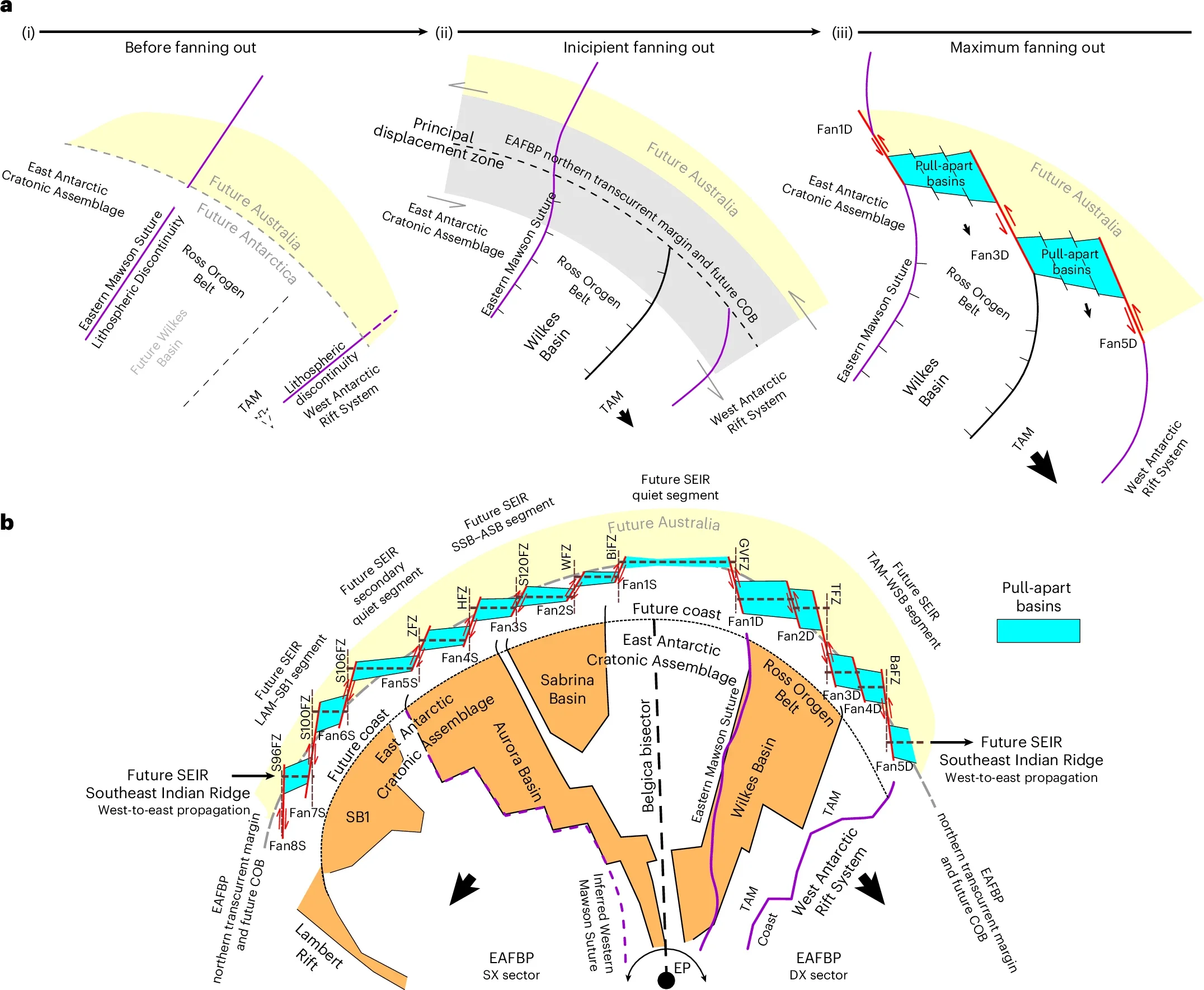
The researchers propose that this process unfolded in at least two phases. In the first, large twin basins opened symmetrically on either side of a central dividing line called the Belgica Bisector. In the second, more strain built up toward the north, and additional deformation produced offsets, secondary basins and a more segmented structure.
That later phase may help explain other longstanding Antarctic puzzles. The Transantarctic Mountains, for example, show a clockwise deflection of about 20 degrees at one point, and the team interprets that bend as part of the same broader tectonic story. The mountains also appear split into three main blocks, matching circular shear belts traced across the buried province.
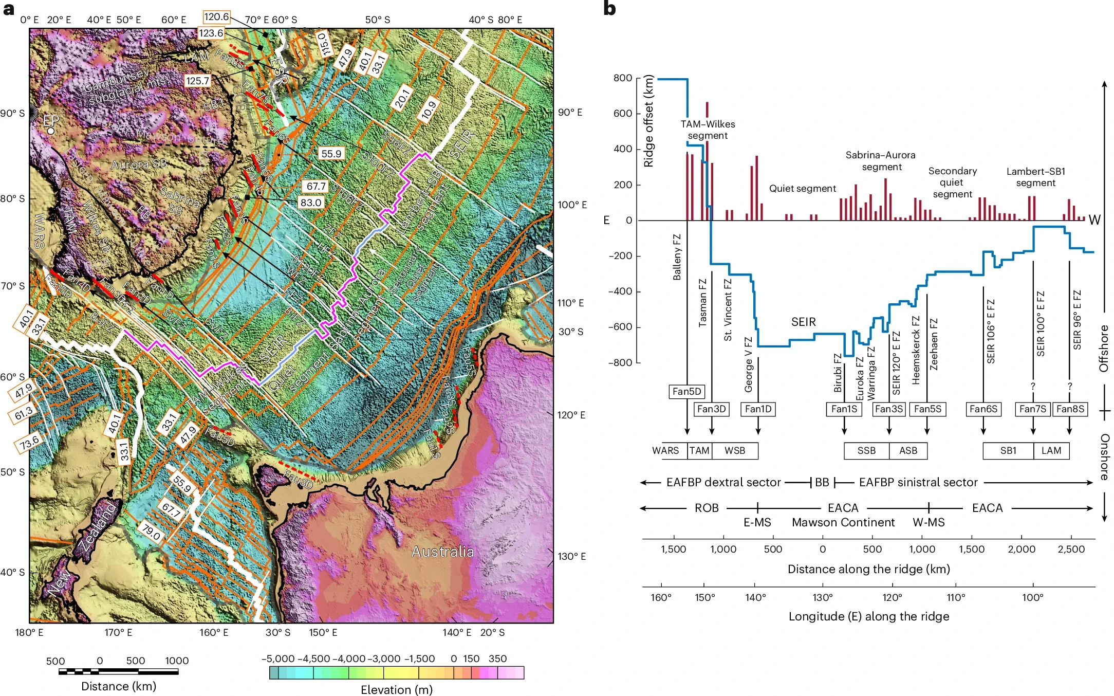
The implications reach beyond Antarctica’s interior. According to the team, the fan-shaped system may have influenced the later breakup between Antarctica and Australia and helped shape the curved geometry of the continental margin and nearby ocean fracture zones.
Offshore, the fracture zones in the Southern Ocean line up strikingly with major onshore structures in the buried province. The authors argue that the northern edge of the fan may have evolved into a release-fault system that later guided rifting and ridge propagation as the continents separated.
That idea would place the East Antarctic Fan-Shaped Basin Province among the largest known examples of rotational extension in continental crust. It also suggests that the structure may have developed through multiple tectonic episodes tied to the long evolution of Gondwana, including Jurassic, Cretaceous and perhaps later reactivation.
The timing, though, remains uncertain. The authors are explicit about that. Thick ice cover prevents direct observation across much of the continent’s interior, and uncertainties remain about the history of the Transantarctic Mountains and the West Antarctic Rift System. The fan-like extension could be multiphase, superimposed on older structures and later reworked by younger tectonic and mantle processes.
So the discovery clarifies one pattern while opening several new questions, including when exactly the system formed and what geodynamic mechanism drove it.
The finding is not just a piece of tectonic detective work. The shape of the bedrock beneath the ice still helps control the way ice moves across East Antarctica today.
The province underlies about half of the East Antarctic Ice Sheet, and the basins and structural boundaries appear to guide major outlet glaciers around the continent’s margin, including Totten, Vanderford, Denman, Frost and Amery. In the Transantarctic Mountains, the proposed circular shear belts may also have influenced the paths of glaciers such as Byrd, Beardmore, Nimrod, David, Priestley and Tucker.
That means a tectonic process that may have begun around 150 million years ago could still be shaping Antarctic glacial behavior now. Sedimentary basins interact with overlying ice through feedbacks that affect retreat dynamics, and some of the post-extension landscape may lie below modern mean sea level, potentially increasing long-term sensitivity in parts of the ice sheet.
The work connects ancient crustal stretching to present-day ice flow in a way that is hard to ignore. Under the frozen surface, the continent still carries the imprint of an older world.
This discovery gives scientists a larger structural map for understanding how East Antarctica works beneath the ice. That matters for more than reconstructing the continent’s tectonic history. Bedrock shape influences where subglacial lakes sit, how glaciers are routed and how ice responds to changing climate conditions.
By identifying this fan-shaped basin province as one linked system, the research could improve models of ice flow, glacial hydrology and long-term ice-sheet stability.
It may also help refine reconstructions of how Antarctica and Australia separated, especially where older models struggle to match crustal blocks and major faults across the two margins.
Research findings are available online in the journal Nature Geoscience.
The original story “Massive fan-shaped structure found hidden beneath East Antarctica” is published in The Brighter Side of News.
Like these kind of feel good stories? Get The Brighter Side of News’ newsletter.
The post Massive fan-shaped structure found hidden beneath East Antarctica appeared first on The Brighter Side of News.


Leave a comment
You must be logged in to post a comment.