The boundary beneath Antarctica’s Thwaites Glacier is less fixed than a line on a map suggests. As tides rise and fall, seawater can push kilometers beneath ice that otherwise rests on the seabed. Melting in that shifting zone could substantially increase the glacier’s contribution to rising seas.
A study published in Nature Communications incorporates those intrusions into an ice-sheet model. The team, involving the University of California, Irvine, NASA’s Jet Propulsion Laboratory and other institutions, first tested whether its simulations could reproduce decades of observed glacier change.
One case projected a sea-level contribution of about 30 millimeters, or 3 centimeters, by 2100 without additional climate warming. That is roughly twice the average contribution from Thwaites in an earlier multi-model comparison under constant forcing. It is a conditional projection, rather than a firm maximum or a forecast of total global sea-level rise.
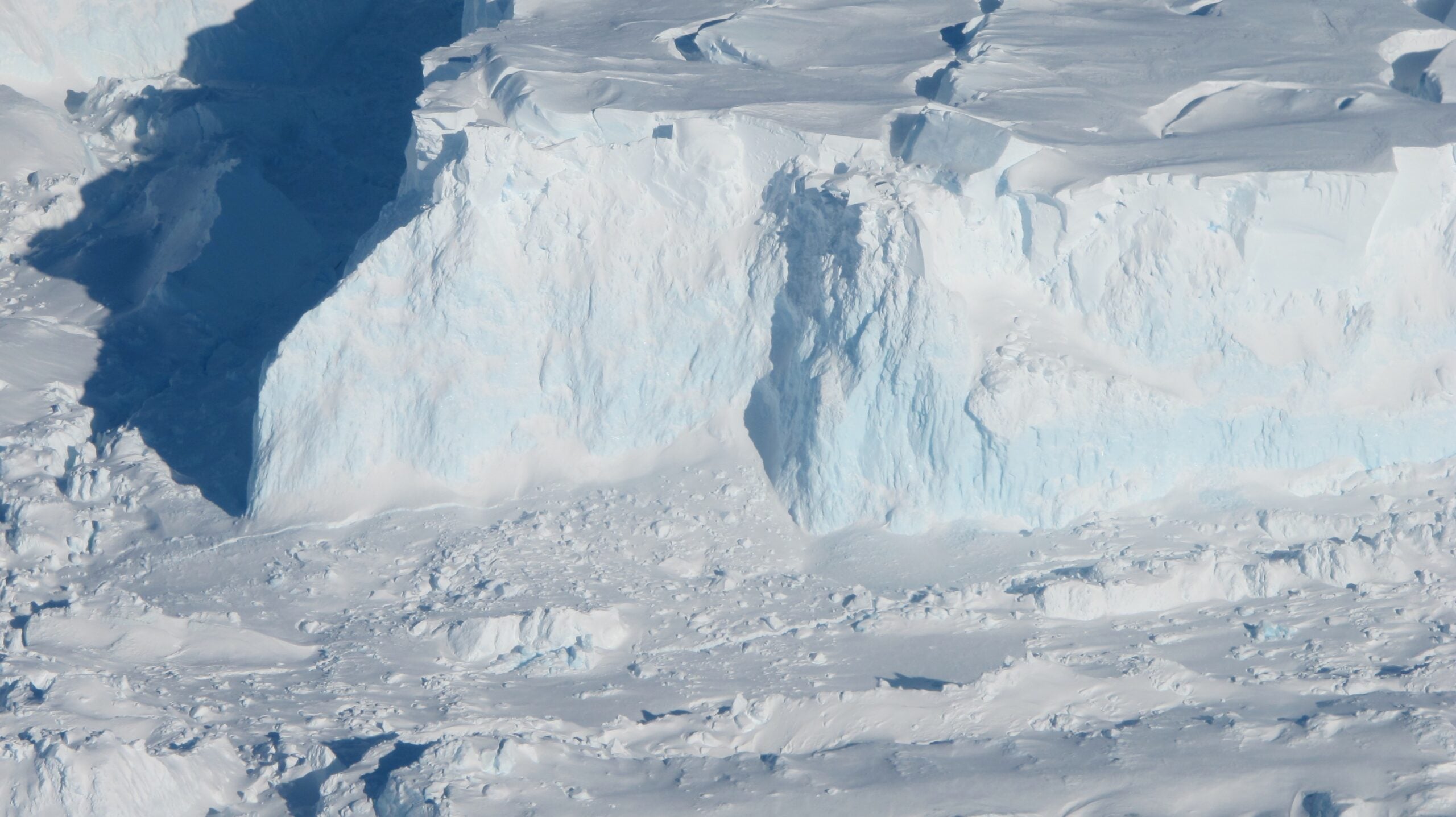
Thwaites occupies part of West Antarctica’s Amundsen Sea Embayment, a region responsible for roughly one-third of Antarctic ice-sheet mass loss. Its fastest-flowing western sector has retreated about 25 kilometers since 1996. The glacier has also thinned and accelerated, changes that models have struggled to reproduce together.
Many models distinguish grounded ice from floating ice at a relatively sharp boundary called the grounding line. Ocean-driven melting is commonly concentrated on the floating side. Satellite observations reveal a more complicated transition, where ice can lift temporarily and admit seawater farther inland.
Losing that contact changes the forces resisting ice flow. As grounded ice moves into the ocean, it contributes to sea-level rise.
Lead author Mattia Poinelli worked on the study as a UC Irvine postdoctoral researcher and is now a UCLA project scientist. He described a “grounding zone,” sometimes kilometers wide, where ocean water reaches underneath the ice. That moving interface changes how researchers represent the glacier’s contact with the sea.
Radar observations from the ICEYE satellite constellation helped establish the scale of these intrusions. Repeated measurements track tidal lifting and settling of the ice. They provide evidence for a broad zone of seawater access that a single fixed boundary cannot fully capture.
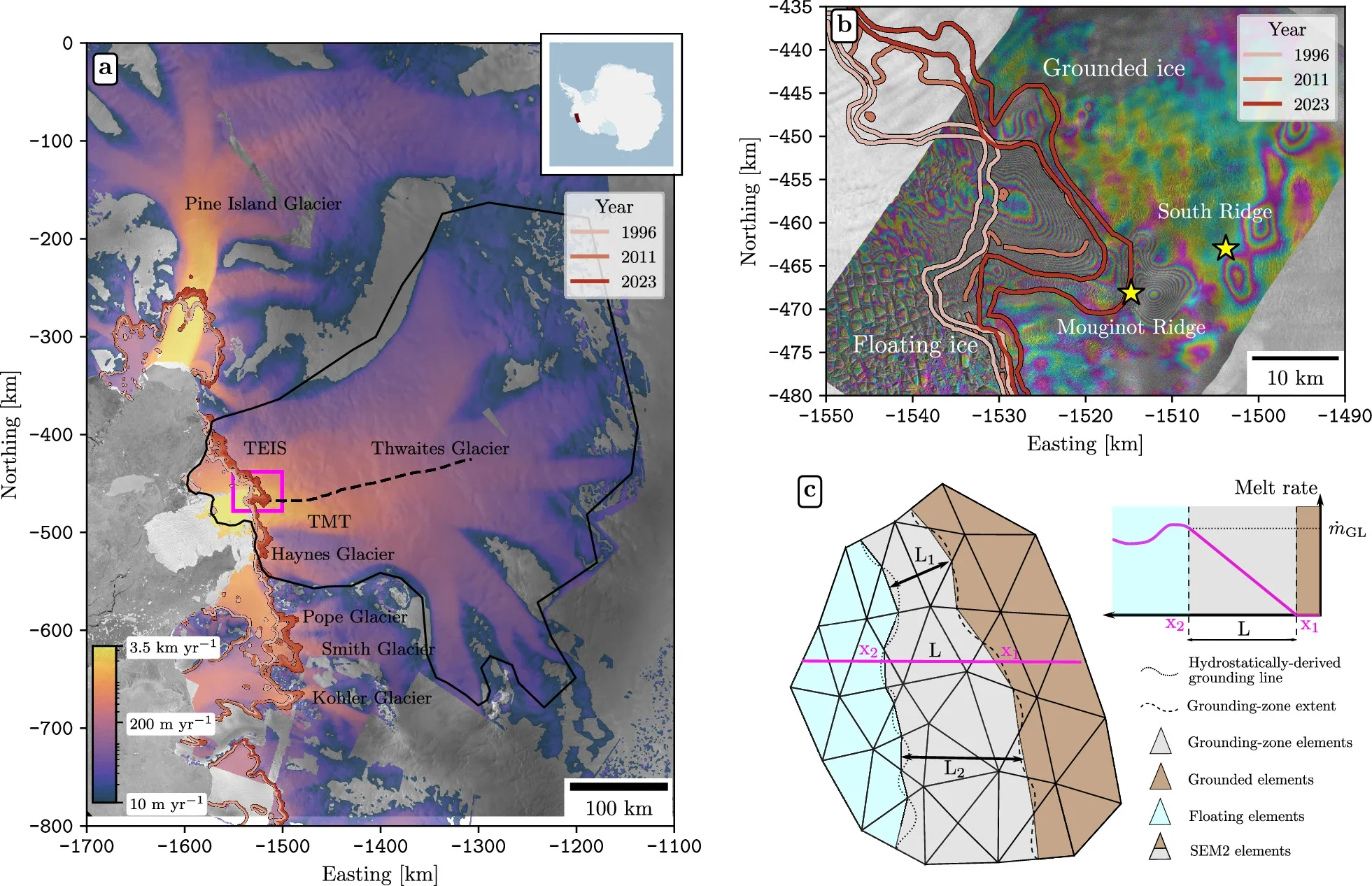
The researchers used the Ice-sheet and Sea-level System Model to simulate Thwaites from 1996 to 2023. They allowed ocean-driven melting to extend inland beneath grounded ice. Different simulations varied the intrusion distance and the rate of submarine melting.
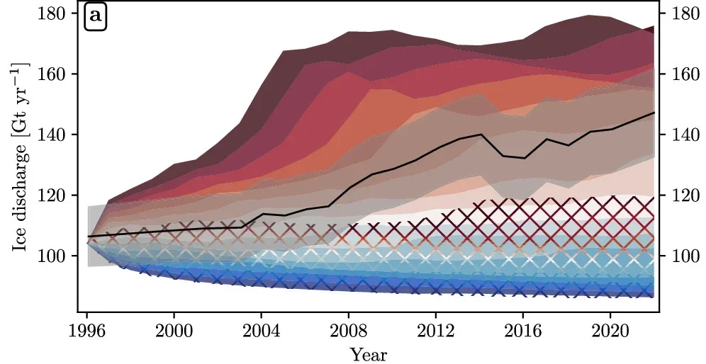
The team compared the results with observations of ice speed, thickness changes and grounding-line positions. Matching several records matters because a model could reproduce one measurement while getting another wrong. The goal was to identify combinations that explained the glacier’s behavior consistently.
The analysis favored grounding-zone lengths of roughly 2 to 5 kilometers, alongside submarine melt rates of 90 to 120 meters annually. Those rates describe melting beneath the ice, not uniform thinning across the glacier’s surface. Different combinations could fit the record, so there was no single uniquely correct setting.
Simulations without a grounding zone were four times less likely to reproduce historical trends in the team’s statistical analysis. This does not mean the observed glacier changes became four times larger. It measures the relative ability of different model configurations to explain changes already documented.
Seafloor geometry also mattered. The researchers raised estimated bed elevations locally by 100 meters, within the stated uncertainty, to make the starting geometry consistent with observations. Even after that adjustment, simulations without grounding-zone melting underestimated important aspects of later retreat and acceleration.
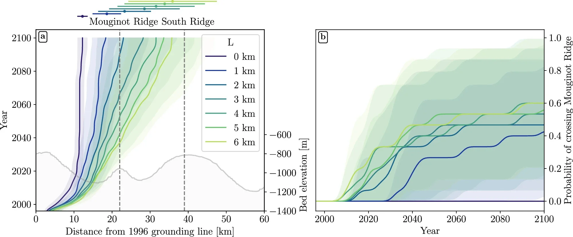
The glacier’s main trunk currently rests against Mouginot Ridge, a seabed high roughly 950 meters below sea level. This feature helps stabilize its position. Melting that reaches farther inland can weaken that support by extending across more of the ridge.
“Once that ridge is unpinned, the glacier will continually retreat across a predominantly retrograde seafloor toward its next topographic high, the South Ridge,” Poinelli said. A retrograde bed becomes deeper inland. In the simulations, that geometry helps sustain retreat after the glacier loses its current foothold.
Simulations using grounding zones 4 to 6 kilometers long produced an approximately 60% probability of retreat beyond Mouginot Ridge by 2100. That percentage belongs to the model ensemble and its assumptions. It is not an independently established probability of complete Thwaites collapse.
Narrower modeled zones produced different outcomes. Cases with 2- to 3-kilometer zones gave an approximately 45% probability of crossing the ridge by century’s end. The contrast shows why the distance seawater penetrates matters for projections.
The future simulations held climate forcing constant, using a baseline derived from average conditions during 1996–2023. This isolates the influence of grounding-zone melting from uncertain future warming. It does not assume that the glacier returns to a colder, undisturbed state or immediately stops responding to existing conditions.
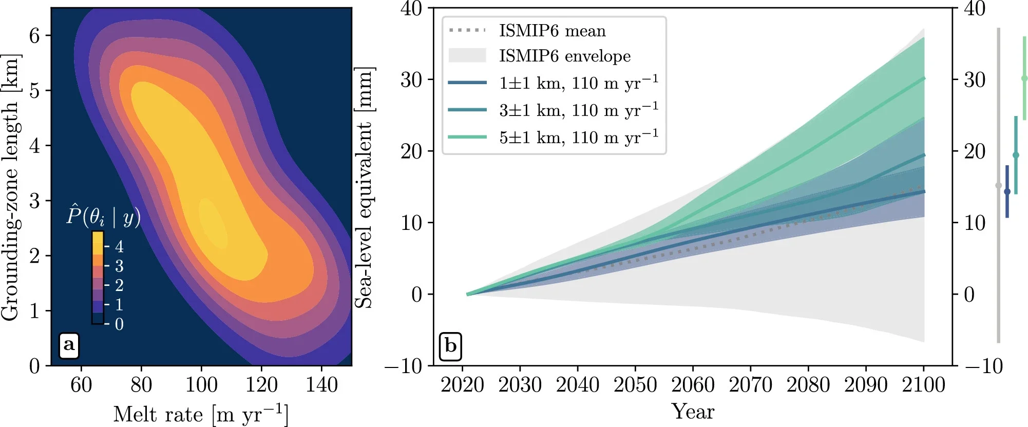
At a selected submarine melt rate of 110 meters annually, a grounding zone of 3 kilometers, with a 1-kilometer variation, yielded 19.4 ± 5.2 millimeters of sea-level contribution. A zone of 5 kilometers, with the same variation, yielded 30.1 ± 5.7 millimeters. These reported spreads underscore that 30 millimeters is not a hard ceiling.
The earlier comparison ensemble averaged 15.2 millimeters under constant forcing, with a much wider spread. Doubling refers to comparing that mean with the approximately five-kilometer case. It does not mean every previous projection underestimated Thwaites by half, and the newer results remain within the earlier uncertainty range.
The improved historical match strengthens the case for representing actively melting grounding zones. However, fitting past observations cannot guarantee a particular future outcome. The model simplifies processes that could alter melting and retreat over coming decades.
It prescribes a fixed effective intrusion length rather than calculating how that distance changes with tides, slopes and subglacial water pressure. It also holds the ice front fixed, excluding calving and frontal retreat. Ocean circulation beneath the changing ice shelf is represented through simplified melting rules rather than a fully coupled simulation.
More measurements of temperature, salinity and circulation beneath the ice could help resolve those uncertainties. The immediate lesson is that seawater reaching grounded ice can materially change projections. Accounting for that hidden contact offers a clearer basis for assessing Thwaites’ future contribution to coastal risk.
These studies examine seawater intrusions, underwater melting and the uncertainty surrounding Antarctic sea-level projections.
Widespread seawater intrusions beneath the grounded ice of Thwaites Glacier, West Antarctica: Documents tidal movement and kilometer-scale seawater access beneath grounded ice using repeated satellite radar observations. (Proceedings of the National Academy of Sciences, 2024)
Contrasting melt regime in the Ice Grounding Zone of Thwaites Glacier, West Antarctica: Investigates how ocean conditions and melting vary within the glacier’s grounding zone. (Proceedings of the National Academy of Sciences, 2025)
Layered seawater intrusion and melt under grounded ice: Explores how seawater can penetrate beneath grounded ice and affect glacier loss in numerical experiments. (The Cryosphere, 2022)
Tipping point in ice-sheet grounding-zone melting due to ocean water intrusion: Examines feedback between melting and seawater penetration that can sharply change grounding-zone behavior. (Nature Geoscience, 2024)
Evolution of the Antarctic Ice Sheet Over the Next Three Centuries From an ISMIP6 Model Ensemble: Compares Antarctic projections across ice-sheet models and climate conditions, providing context for their substantial uncertainty. (Earth’s Future, 2024)
Research findings are available online in the journal Nature Communications.
The original story “Hidden seawater beneath Thwaites Glacier could substantially raise sea levels” is published in The Brighter Side of News.
Like these kind of feel good stories? Get The Brighter Side of News’ newsletter.
The post Hidden seawater beneath Thwaites Glacier could substantially raise sea levels appeared first on The Brighter Side of News.


Leave a comment
You must be logged in to post a comment.